
 Donation
Rasuwa Debris Flash Flood 2026
26 August 2026
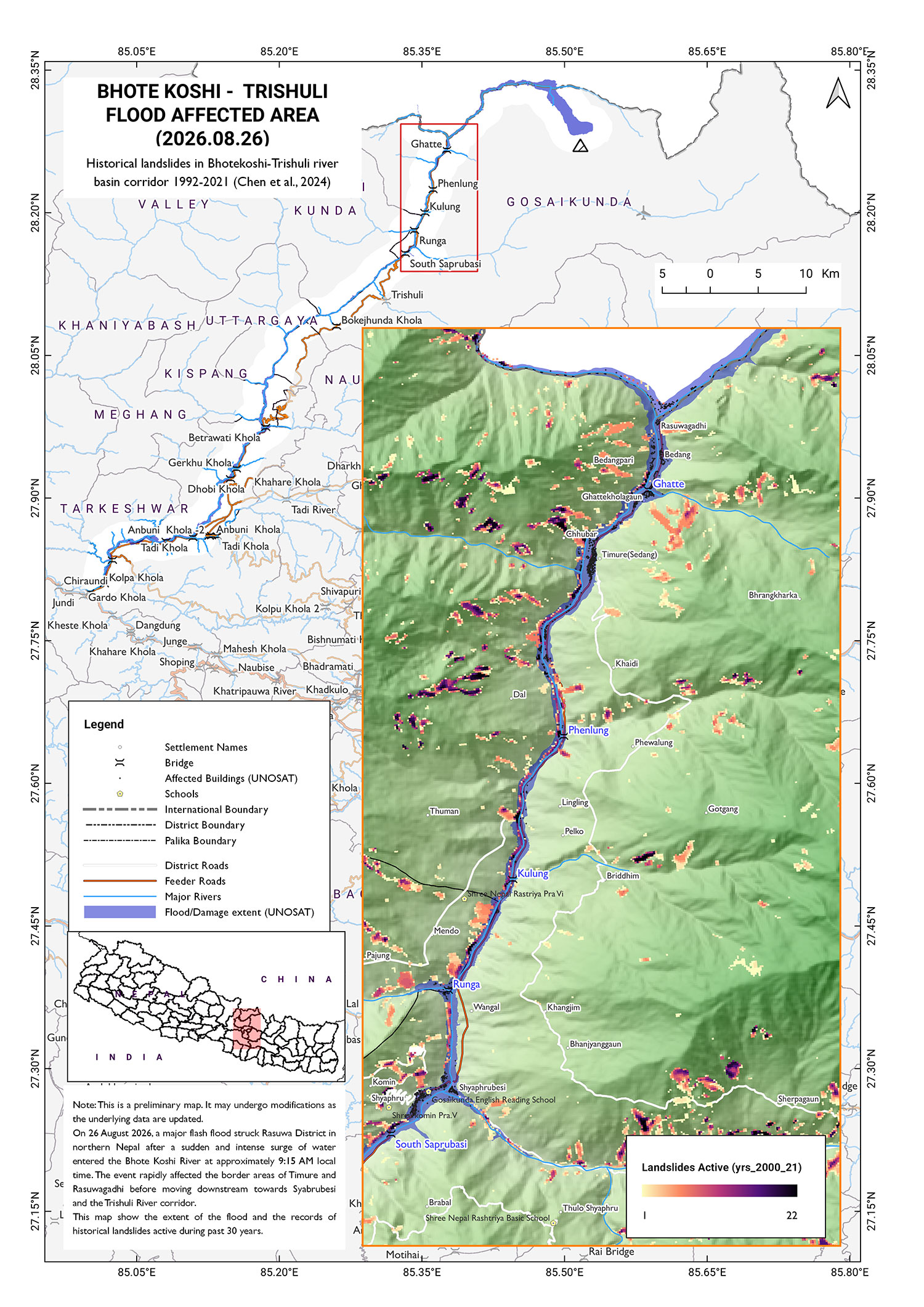
On 26 August 2026, a major ice–rock avalanche occurred in the upper Bhote Koshi watershed near the China-Nepal border, approximately 20 km upstream of Rasuwagadhi. Preliminary analysis based on high-resolution satellite imagery indicates that the event originated from a north-facing slope near the Lhende River, where an estimated 1 km² section of rock-glacier material detached and rapidly moved downslope. The detached ice and rock mass generated an ice–rock avalanche that entrained loose proglacial sediments along its downstream path, transforming into a highly mobile sediment- and water-laden debris flow. Initial assessments suggest that the resulting outburst flood in the upper watershed exceeded the magnitude of normal seasonal flooding by an order of magnitude or more.
A seismic signal equivalent to a magnitude greater than 5 Mw earthquake was recorded near the Langtang/Lirung area, close to the identified avalanche source zone. Subsequent analysis confirmed that the seismic signal was generated by the large mass movement itself and was not the triggering cause of the event. Following the avalanche and debris-flood process, multiple temporary lakes formed along the downstream flow path due to channel blockage and sediment deposition. Satellite and drone observations have confirmed that some of these lakes have already drained; however, continued formation of temporary impoundments remains possible due to ongoing bank instability, channel obstruction and intense rainfall. As a result, residual risks remain from sudden river damming, lake breach floods, additional debris flows and secondary flooding events.
The event affected the Bhote Koshi–Trishuli–Narayani river corridor, a critical north–south transboundary river system extending from the Tibet–Nepal border through Rasuwa, Nuwakot, Dhading, Gorkha, Chitwan, Tanahun and Nawalparasi. The corridor contains strategically important infrastructure, including the Rasuwagadhi border crossing, customs and immigration facilities, major settlements, tourism routes, public services, and hydropower projects such as Rasuwagadhi, Chilime and Trishuli. Rasuwa represents a particularly vulnerable section due to its steep terrain, active geological conditions, concentrated settlements, and critical infrastructure located within a narrow mountain valley.

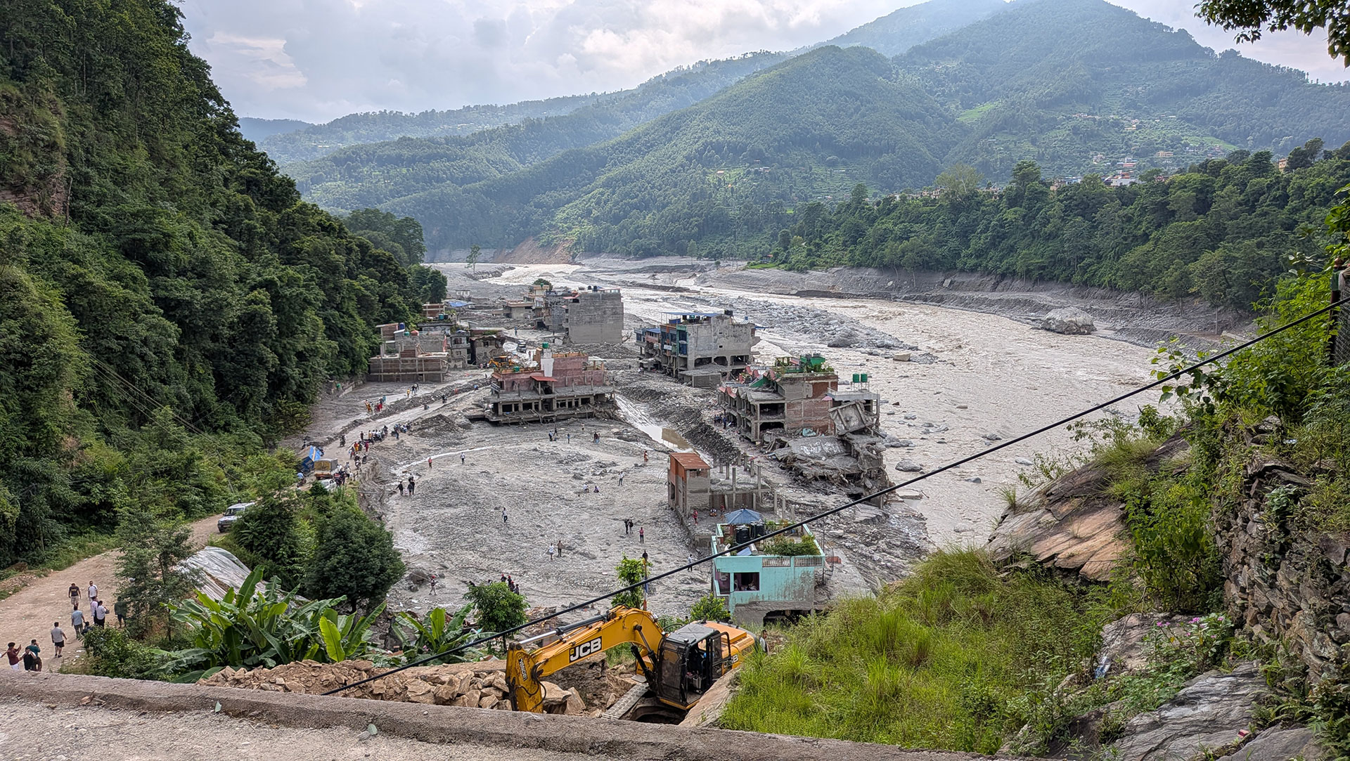
The event transformed from a high-altitude transboundary ice–rock avalanche into a multi-hazard flood and debris-flow emergency, affecting multiple districts along the Bhote Koshi–Trishuli–Narayani corridor. Ongoing risks remain from temporary river blockages, sudden breach floods, additional debris flows and rainfall-triggered secondary hazards, requiring continued monitoring, early warning and coordinated disaster response.
What are we doing
- Providing technical support to the Government of Nepal in disaster response planning.
- Supporting temporary shelter options and coordinating with relevant stakeholders to identify appropriate solutions.
- Supporting school restoration and learning continuity in disaster-affected areas.
- Exploring opportunities for scientific studies and assessments in collaboration with national and international scientific communities.
Causality and SAR Updates (Sept 26, 2026_NDRRMA)
- 1,453
- Total Deaths
- 5,285
- Total Missing Persons
- 13,795
- Total Rescued
- 2,106
- Helicopter Flights
- 1,109
- People in Holding Centers
- 3 Severely Impacted
- Rasuwa, Nuwakot, Dhadin
- 5 Other Affected Districts
- Gorkha, Chitwan, Tanahun, Nawalparasi East, Nawalparasi
- 15
- Affected Local Governments
- 20,477
- Security Mobilized
- NPR 15,000 (4 Family Members,+ per member NPR 2000)
- Housing and Livelihood Grant (Up to 6 month)
Sectoral Impacts
People and Housing Impacts
An estimated 7,570 private buildings, 8,317 households, and 32,963 people were affected across 15 local levels in the assessed areas. The disaster caused significant impacts on housing and living conditions, with damage to homes contributing to displacement and disruption of household life. The assessment highlights the need for safe temporary accommodation, housing recovery, and resilient reconstruction, particularly for households facing greater challenges in accessing assistance and recovering their livelihoods
Infrastructure and Connectivity Impact
Infrastructure accounted for 46.55% of the total disaster effects, making it the most significantly affected major sector. The disaster caused extensive disruption to roads, bridges, energy, telecommunications, water supply, sanitation, and other critical infrastructure, affecting access to communities and essential services. The assessment recorded 37 motorable bridges and 68 trail-bridge spans, of which 33 motorable bridges were washed out and four were partially damaged. The damage to transport networks significantly constrained rescue, relief, assessment, and recovery operations, particularly in affected and isolated communities.
Energy and Hydropower Impact
The assessment recorded 13 hydropower projects with a combined capacity of 759.03 MW including 7 operating projects (250.40 MW) and 6 projects under construction (508.63 MW). The energy sector sustained USD 889.21 million in physical damage, with estimated recovery needs of USD 2.58 billion
Livelihood and Economic Impacts
The disaster caused significant disruption to local livelihoods and economic activities across the affected river corridor. The productive sector recorded USD 992.70 million in total disaster effects, including USD 200.05 million in physical damage and USD 765.07 million in economic losses. Economic activities and livelihoods alone accounted for 86.61% of all assessed economic losses, affecting businesses, employment and household income. An estimated USD 300.08 million is required to support recovery of economic activities and livelihoods.
Social Sector Impacts
The social sector recorded USD 448.05 million in total disaster effects, with private buildings accounting for 94.15% of sector damage. The assessment also identified impacts on public buildings and facilities, schools, health facilities and cultural heritage. An estimated USD 683.59 million is required for social-sector recovery, including restoration and reconstruction of housing and essential services.
Disaster Risk Reduction Impacts
The assessment estimates USD 625.52 million in recovery needs for disaster risk reduction (DRR). Proposed measures include risk-informed reconstruction, safer siting, resilient infrastructure and strengthened preparedness and early-warning arrangements. Integrating DRR into recovery is particularly important given the continuing risks from unstable slopes, accumulated sediment, obstructed channels and potential secondary flooding and debris flows.
Inclusive Recovery Impacts
Children, older people, persons with disabilities, pregnant and breastfeeding women, and households with limited savings, access to credit or livelihood options may face greater challenges in accessing assistance and recovering their lives and livelihoods. The assessment therefore emphasizes inclusive, equitable and risk-informed recovery, with household verification and assistance planning considering factors such as displacement, tenure, livelihood interruption, unmet needs, and sex-, age- and disability-disaggregated information.
Overall Disaster Impact
USD 2.70 billion in total disaster effects, including USD 1.81 billion in physical damage and USD 883.32 million in economic losses-with USD 4.77 billion estimated for recovery and reconstruction.
Situation Reports (NDRRMA )